QGIS Data Provider Data Parsing Problems
The parsing of datasets by QGIS data providers is silent and can change both geometry sub-type and the geometry data values of null and Empty (Table 12).
Changes of geometry sub-type may be required because the data source doesn’t support the mixing of specific sub-types, or, because the source sub-type may not be supported at all. For example, in Table 12, neither Geopackage nor Spatialite permit the mixing of Line and Multi-Line subtypes, so, the data provider defaults to the Multi-Line subtype for the creation of a new dataset, and, all records with a Line subtype are changed to a Multi-Line subtype. In an another example, Shapefile does not support the Line subtype at all, with all records with a Line subtype changed to a PolyLine [2].
For geometry data vales of null and empty, values are changed as the data source does not permit both types, or, because the data provider contains errors. In Table 12 it is shown that with the exception of the PostGis format, either the parsing of the known geometry data value of empty is changed to the unknown value of null, or, visa versa. The replacement of known with unknown, or unknown with known can cause erroneous analysis and interpretation. Without experience errors may be introduced into datasets by the parsing of data by QGIS’s data providers.
| QGIS memory | Geopackage | Shapefile | Spatialite [7] | PostGis [5] | MS SQL [5] |
|---|---|---|---|---|---|
| Multi-Line | Multi-Line | Polyline | Multi-Line | Multi-Line | Multi-Line |
| Line | Multi-Line | Polyline | Multi-Line | Line | Line |
| Empty | Empty | null | Empty | Empty | null |
| null | Empty | null | Empty | null | null |
Parsing Geometry Data Types
The parsing of geometry records by the QGIS data providers often requires changing the geometry sub-type. For example, consider the parsing of geometry subtypes between ESRI’s Shapefile, QGIS, and, SpatiaLite (Fig. 11). SpatiaLite and Shapefiles have a single geometry sub-type defined for a dataset [6] which is simpler than data sources like Microsoft SQL Server and PostGIS where the geometry sub-type can vary for each record.
The hierarchy for the ubiquitous Shapefile shown in Fig. 7 is vastly different to that for QGIS [12]. For constructing a single part line, QGIS has the four geometry subtypes of “Multi-Line”, “Circular-String”, “Compound-Curve”, and, “Line”, whereas Shapefile only has the single subtype of “PolyLine” [1]. Hence, in a QGIS editing session, a user may create a line using any of QGIS’s four line subtypes, but, the line will only be recorded as a “PolyLine” and it is the Provider’s task to inform QGIS of this requirement (Fig. 11).
In comparison to a Shapefile, SpatiaLite has the Multi-Line and Line sub-types and QGIS has to distinguish between these. The manner in which QGIS distinguishes between a Multi-Line and a Line for parsing to SpatiaLite is primitive. A single part QGIS Multi-Line can’t be parsed to a SpatiaLite Line as the provider refers to the geometry type and not the number of parts, but, a “Line” will be converted to a Multi-Line by silently changing it’s geometry type if it is parsed to a SpatiaLite Mutli-Line data source. In a similar manner, Circular-String and Compound-Curve sub-types will be converted to Line sub-types, and then Multi-Line sub-types if required. Some of the geometry sub-type changing may confuse unwary users, for example, a SpatiaLite Line data source read by QGIS and saved as a SpatiaLite Multi-Line is silent and without error or warning, however, the newly created SpatiaLite Multi-Line can’t be then saved as a SpatiaLite Line by QGIS without the use of a tool that changes the geometry type to Line, even though each Multi-Line only has one part.
Editing existing geometries or creating new geometries creates similar challenges for parsing geometry types. Any geometry edit or creation has to occur on a QGIS geometry sub-type and then parsed to the data source. In an edit process, QGIS will allow incompatible geometries to be created and it is only when the edited geometries are attempted to be committed to the data source that QGIS either throws an error or changes to a compatible geometry sub-type.
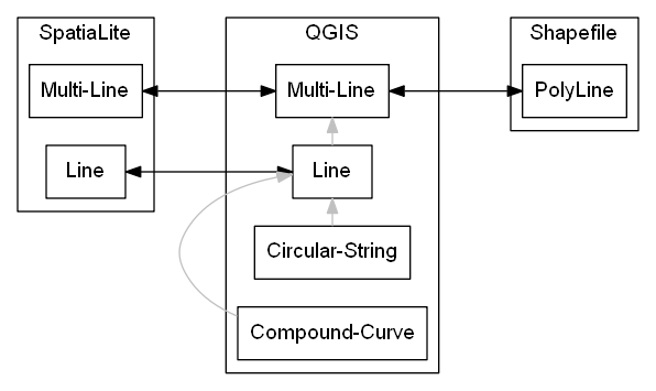
Fig. 11 The association of various geometry Line sub-types for SpatiaLite, QGIS and Shapefile: grey arrows refer to changes in geometry sub-type within QGIS prior to committing data; black arrows indicate data parsing between QGIS and the external data sources.
Data Provider Geometry Type Errors
There is a great diversity in both the refinement and development of each QGIS data provider. As QGIS is opensource, the varying levels of refinement of different data providers may reflect communities of users or the commissioning of developers. Given the complexity of the data providers task of parsing datasources to and from QGIS, it is not surprising that there are many unexpected errors originating from the data parsing process.
For example, for a memory data source, QGIS allows the mixing of primitive and multi-part geometries of the same dimensionality. The insertion of a Line geometry subtype record into a Multi-Line geometry subtype for a QGIS memory data source is demonstrated by Python script using the QGIS API:
>>> from qgis.core import *
>>> layerMulti=QgsVectorLayer('MultiLineString?crs=epsg:4326&field=ID:string', 'a', "memory")
>>> providerMulti=layerMulti.dataProvider()
>>> recordWrite = QgsFeature()
>>> recordWrite.setAttributes(['1'])
>>> recordWrite.setGeometry(QgsGeometry.fromWkt('LINESTRING (1 1, 6 1)'))
>>> providerMulti.addFeature(recordWrite)
True
>>> recordRead = layerMulti.getFeature(1)
>>> print(QgsWkbTypes.displayString(recordRead.geometry().wkbType()))
LineString
>>> print(QgsWkbTypes.displayString(layerMulti.dataProvider().wkbType()))
MultiLineString
More worryingly, as shown in the next Python script, the reverse is also possible. One may add a feature with a Multi-Line geometry sub-type into a Line QGIS memory dataset.
>>> from qgis.core import *
>>> layerSingle=QgsVectorLayer('LineString?crs=epsg:4326&field=ID:string', 'b', "memory")
>>> providerSingle = layerSingle.dataProvider()
>>> recordWrite = QgsFeature()
>>> recordWrite.setAttributes(['1'])
>>> recordWrite.setGeometry(QgsGeometry.fromWkt('MULTILINESTRING ((1 1, 6 1), (1 2, 6 2))'))
>>> providerSingle.addFeature(recordWrite)
True
>>> recordRead = layerSingle.getFeature(1)
>>> print(QgsWkbTypes.displayString(recordRead.geometry().wkbType()))
MultiLineString
>>> print(QgsWkbTypes.displayString(layerSingle.dataProvider().wkbType()))
LineString
Fortunately with a QGIS memory dataset you can’t insert a Point into a Line dataset, or, otherwise mix geometry sub-types of different dimensionality.
>>> from qgis.core import *
>>> layerSingle=QgsVectorLayer('LineString?crs=epsg:4326&field=ID:string', 'b', "memory")
>>> providerSingle = layerSingle.dataProvider()
>>> recordWrite = QgsFeature()
>>> recordWrite.setAttributes(['1'])
>>> recordWrite.setGeometry(QgsGeometry.fromWkt('POINT (1 1)'))
>>> providerSingle.addFeature(recordWrite)
False
Parsing Empty and null Geometry Data Values
The instantiation process for empty and null data values in QGIS is very different dependent on whether the value is empty or null.
Instantiation of Empty Geometry Values by QGIS
An empty geometry is a geometry value with an empty set of vertices. Hence, an empty Line geometry value is distinct to an empty Multi-Line geometry value. As the geometry sub-type is associated with an empty value, the method for instantiating empty geometries is embedded within each geometry subclass that can be instantiated. Unfortunately, there is some variation with how QGIS instantiates empty geometry values across different geometry subclasses.
Using the QGIS API, empty geometries for several geometry types can be instantiated by instantiating the relevant QgsAbstractGeometry subclass without a set of vertices. For example, to test that a QgsLineString() is empty:
>>> from qgis.core import QgsLineString
>>> QgsLineString().isEmpty()
True
Although empty geometries can be created for most geometry types with the QGIS API by instantiation without a set of vertices, it is not currently possible to instantiate an empty point geometry using this approach (Table 13). As demonstrated below, the well known text representation of the call to instantiate an empty point reveals that QGIS is wrongly adding a vertex with the coordinates of \((0\ 0)\) [8] [3].
>>> from qgis.core import QgsLineString,QgsPoint
>>> print(QgsLineString().asWkt())
LineString ()
>>> print(QgsPoint().asWkt())
Point (0 0)
>>> print(QgsPoint().createEmptyWithSameType().asWkt())
Point (nan nan)
| Input | Output |
|---|---|
QgsPoint().isEmpty() |
False |
QgsLineString().isEmpty() |
True |
QgsPolygon().isEmpty() |
True |
QgsGeometryCollection().isEmpty() |
True |
Changing of Empty data Values by parsing
As indicated in Table 12 empty geometry values are changed to null when parsing to Microsft SQL server or Shapefile data sources. For a Shapefile, this change in data value maybe the most pragmatic outcome as empty geometries are not included in it’s specification. For the Micrsoft SQL Server data source, the change from empty to null occurs when parsing to or from this data source [28] although both QGIS and Microsoft SQL Server specifications include empty geometry data values. In contrast to Microsoft SQL Server, empty and null values are parsed to and from PostGIS without fault or change.
Inadvertently Creating Empty Geometries within QGIS
Within QGIS, an empty geometry is created by using the “Vertex Tool” to delete all vertices of an existing shape. A user unfamiliar with QGIS may incorrectly assume that deleting all the vertices of a geometry also deletes the record. This mistake of assumed record deletion when deleting vertices is most likely to occur for geometries with single part points as the geometry disappears from view when the first and only vertex is deleted. Hence, when editing a shape, a QGIS user may unintentionally create an empty shape when they are attempting to delete the shape.
In QGIS null Implies Empty
In the definition of empty geometry values in section Empty it is articulated that an empty geometry is just one valid value in the set of valid values for the geometry data type. In contrast, null indicates that the geometry value is unknown and that the value can be any value from the set of valid values. Hence, an empty geometry values is one of many possible values for a null geometry. For example, for a point, the vertices of an empty point are \(\{\ \ \}\) as it has no coordinates, and, the vertices of a null point are \(\{x\ y\}\) where \(x\) and \(y\) are both variables designating unknown coordinates. These definitions are consistent with SQL relational databases. Unfortunately, the application of null used by SQL relational databases is different to that used by both mathematics for set theory, and, by most computer programming languages [6].
Let’s consider the definition of null for set theory and computer programming using a common example. If one has a box of apples and a box of bananas, then the intersection of the two boxes of fruit is an empty box. For set theory, null – nothing is what you have when you take away the box.
Similar to set theory, for most object-oriented computer programming languages, an object that has not been instantiated is null. Hence, a pointer to something that doesn’t exist is null. In comparison, an empty object is an object that has been instantiated but not populated, for example, a list with no members, or, a box with no fruit.
So, from the perspective of an object-oriented computer programming language, null means no value and no type. Hence, a null object is an object that does not exist and does not occupy space in a computer’s memory. Indeed, SQL relational databases implement null as an object that doesn’t exist, so, the context difference between unknown and nothing does not have to create conflict.
The underlying conflict is based on logical deduction. It has been proved that an empty set is a subset of any set. Some argue that on object that doesn’t exist can’t contain anything, so, it must be empty [4]. Hence, null is a subclass of empty. This argument is flawed as by arguing that a null object is empty you have just created an object. A null object neither contains anything nor has a container.
Unfortunately, many computer programming languages and QGIS follow a convention where something must also be empty if it is null. QGIS employs the logic that a null geometry is also an empty geometry [13]. The QGIS test for null in it’s C++ code simply asks whether the object exists (whether it points to anything) [13]:
144 bool QgsGeometry::isNull() const
145 {
146  return !d->geometry;
147 }
Now, the QGIS test for empty in it’s C++ code performs the same test as for null, and, returns True if the test for null returns True [13]:
329 bool QgsGeometry::isEmpty() const
330 {
331  if ( !d->geometry )
332  {
333  return true;
334  }
335
336  return d->geometry->isEmpty();
337 }
Hence, a test for an empty geometry in QGIS will return True for all null and empty geometry values.
>>> from qgis.core import QgsFeature
>>> recordNull, recordEmpty = (QgsFeature() for i in range(2))
>>> recordEmpty.setGeometry(QgsGeometry.fromWkt('LINESTRING ()'))
>>> # Only recordNull has a null geometry
>>> recordNull.geometry().isNull()
True
>>> recordEmpty.geometry().isNull()
False
>>> # Both recordNull and recordEmpty have empty geometries
>>> recordNull.geometry().isEmpty()
True
>>> recordEmpty.geometry().isEmpty()
True
Instantiation of null Geometry Values by QGIS
To claim a null geometry value has been instantiated in QGIS is a faux pas. null represents the absence of a value, so, a record with a null geometry value is a record without a geometry value. null infers that an object (in this case a geometry value) has not been instantiated.
Retrospective Incorporation of Empty and null Values Into GDAL
The Geospatial Data Abstraction Library (GDAL) is ubiquitous within most GIS Software to translate and process geospatial data. Handles for empty geometries were not part of the original GDAL specification, with empty geometries being treated as null. The retrospective incorporation of empty handles into GDAL has not been picked up by many applications that employ GDAL, and, even within GDAL there are many processing tools that don’t maintain empty geometries.
Many of the current GDAL set operators continue to convert empty geometry values to null geometry values even when the set being operated on has successfully implemented the empty geometry handle on parsing to GDAL. For example, for the intersection operation the output is “a new geometry representing the intersection or NULL if there is no intersection or an error occurs” [4]. Curiously, the same GDAL geometry class has a handle to assign an empty geometry, or, to test for an empty geometry [1]. On another GDAL ticket register it is stated “GML/WFS: by default does not advertise NOT NULL fields since we treat empty strings as being null for historical reasons. By setting the open option EMPTY_AS_NULL=NO, empty strings will be reported as such and NOT NULL fields might be advertised” [24]. It is clear that GDAL was not originally intended to distinguish between null and empty.
The retrospective addition of handles for empty geometry values in GDAL was mimicked by QGIS. Consequently, within QGIS there are many tools that convert empty values to null during their operation.
| [1] | The QGIS types were renamed here for clarity. The actual QGIS types are QgsLineString, QgsCircularString, QgsCompoundCurve, and, QgsMultiLineString. |
| [2] | A Shapefile’s PolyLine is essentially the same as a Multi-Line for the scope of this report. |
| [3] | a Point (nan nan) is also reported when an empty PostGis point is parsed by QGIS. |
| [4] | Unable to find a high quality reference for this argument. Several private conversations with C++ programmers reveal that this logic is common and is frequently used to test for empty in C++. |
| [5] | (1, 2) The geometry type saved by PostGis and Microsoft SQL server depends on: geometry constraints within the database; the use of a Geometry columns lookup table; and, what geometry types already exist within the respective datasets. |
| [6] | Technically in a Shapefile the geometry sub-type is recorded for each record, but, the technical specifications state that “All non-null shapes must be of the same shape type” [18]. |
| [7] | SpatialLite table has a Multi-Line geometry data type. |